Category Archives: online

To video, or not to video?

“That is the question.”

(Apologies to anyone who has studied English Literature, at any level!)

With nearly everyone participating in more and move video calls, “to share video or not to share video” is, indeed, the question. When participating in an online conference, should the audience members share their video?

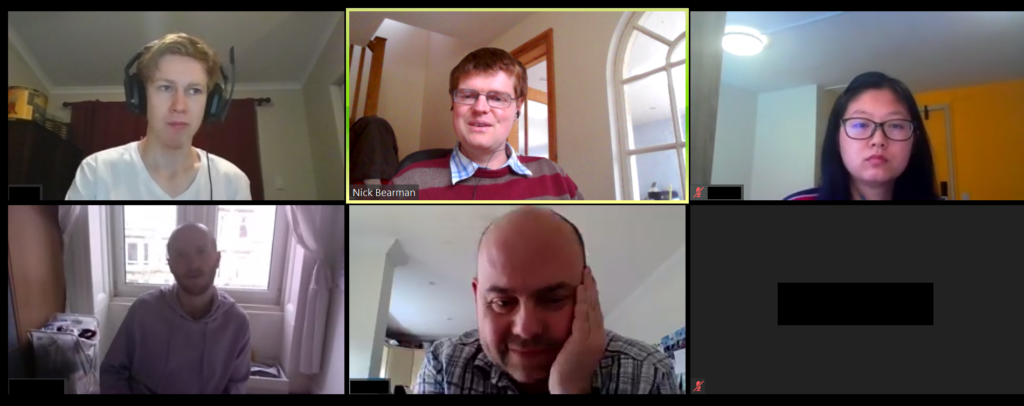
We have all attended loads of video conferencing calls over the last 15 months, and I’ve been no expectation to this. I attended two conferences recently, and one thing that struck me was whether the audience members have their cameras on.

When I’m running a training course or presenting, I really love to be able to see people’s faces – so I can see who I am talking to. Of course, I realise this isn’t always possible or something the participants want to do (either because of bandwidth limitations, not having a suitable home environment [although this is less of an issue with virtual backgrounds now] or many other reasons). Therefore when I am running a course I explicitly say at the beginning:
“If you can have your video on and would like to, please do. I really like to be able to see people. However if you have limited bandwidth, or another reason why you don’t want to share your video, that is fine as well.”
With this approach 9 out of 10 people usually put their video on and it makes it a much better experience for me (and, I think for them).

Participants in one of my training courses sharing their videos

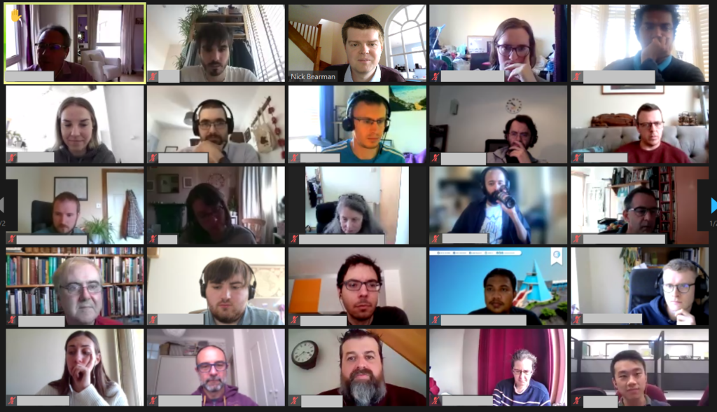
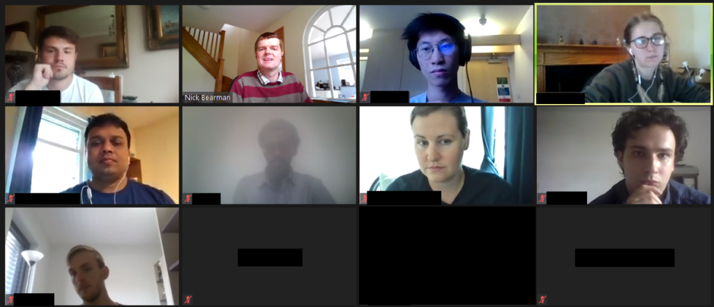
I recently attended two conferences (AGILE 2021 and Coding in the Open), where only the people presenting shared their video, and the attendees did not. There have been many conferences like this, and at some conferences attendees do not have a choice (e.g. if you are using Zoom Webinar, the audience can not share their video).

However for these conferences, there was a choice (AGILE used a standard Zoom room, and Coding in the Open used Bluejeans). For AGILE, the organisers asked participants to turn on their cameras for a group photo! About two-thirds or so of people did turn their cameras on the for photo. However as soon as the photo was done, people turned their cameras off again.

Our AGILE group photo (1 of 2).

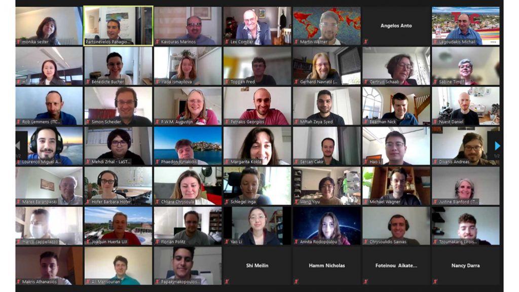
There seems to be an unwritten rule that the audience have their cameras off, and I have seen this is many other conferences as well.

The blank boxes (with names and initials removed)

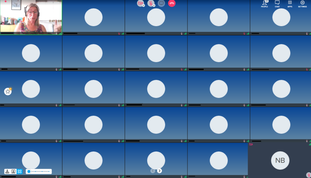
Personally, I don’t really like this, as all you get to see of the other people on the call are black boxes. Yes, you can turn off the blank boxes, but if I am presenting, I like to be able to see who I am presenting to, and if I am in the audience, I also like to see who the audience are.

The other conference I attended was Coding in the Open, and this was run on Bluejeans. Here the attendees were asked to turn of their video because of bandwidth. This is often a worrying concern, and here around 150 had signed up for the free conference, and the organisers were very worried that 150 people joining the call with video might stretch the limits of the platform. In the end, typically we had 40-50 people in each session, so wouldn’t have been an issue.

This is a very common concern for organisers, and compounded by the fact that for free events, often only one third or one half of the people who sign up actually appear. The question then is how much capacity do you need for this event, with additional capacity often costing more money. This is a discussion for another time though.

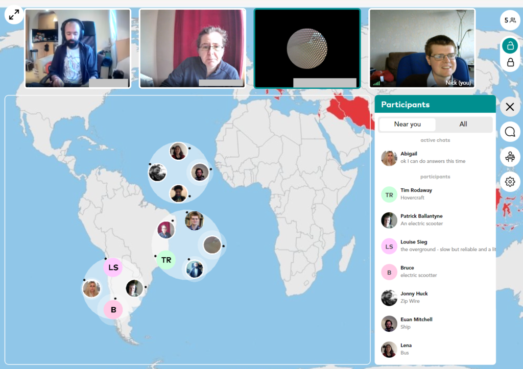
I did a rough show of hands in the session, and it seems most people would prefer to see the audience, whether they are in the audience or the presenter. Additionally, most programs have the option of hiding the video of other participants, if that is what you prefer.

As an aside, it is worth mentioning that you can turn your own video off in most platforms, and apparently this has been shown to reduce tiredness. I’m not sure it makes a lot of different for me, but for some people it clearly does:

So if you think it might help you, give it a try!

I guess as we work out what the ‘new normal’ is, we will be creating new social rules and expectations for how we work, including in video calls. I would say please do share your video if you can – whether you are in a call of 2, class of 25 or lecture hall of 200. I think it makes all the difference to the person presenting!

Do share your experiences in the comments below and let me know what you think.

GISRUK 2021: Online II

We had a great GISRUK conference this year. We were online again (as we were in 2020), because of Covid-19, with Scott Orford at Cardiff University hosting, we had a really smooth running online conference. There was a very strong field of submissions, with 24 short papers and 43 long papers being presented, with a significant proportion being presented by Early Career Researchers. The papers themselves and the recordings are all available on the GISRUK website. Attendance was also very good, with typically >100 people attending the keynotes and >50 people in each of the presentation sessions.

Attendance at GISRUL was very good

I coordinated the Early Career Workshop sessions before the main conference, and while I am biased, I think they went really well, and the ECRs who attended said they were really useful sessions. The main sessions were on Zoom, and we also experimented a bit with the Wonder.me platform for a quiz and networking, which worked really well.

Quiz and Social on Wonder.me

As ever with GISRUK we had an incredibly wide range of topic presented, from new spatial methods to big data, spatial inequalities and participatory GIS. Uber’s H3 hexagonal grid appeared several times, being a really useful new geography for many types of analysis. One of the big positives is the fact that indexing is a lot easier when working with this geography. It was also great to see presentations from the commercial sector, including Tomas Holderness from AddressCloud, presenting on their work with serverless infrastructure.

GISRUK awards prizes, and this year I managed to actually see most of the winners – parallel sessions makes this a challenge, and there have been years I haven’t seen any of the winners! This years winners were.

  • Best Long Paper: 23 Naturally Urban? Tackling Inequalities in Urban Greenspace and Wellbeing, by Victoria Houlden
  • Best Short Paper: 53 Georeferencing historical telephone directories to understand innovation diffusion and social change, by Nikki Tanu, Maurizio Gibin and Paul Longley
  • Best ECR Paper: 65 Do we need legends? An eye tracking study, by Jess Hepburn, David Fairbairn, Philip James and Alistair Ford
  • Best ECR Paper: 48 Geo-information tools for stakeholder engagement in environmental decision-making: “best practice” recommendations from a UK case study, by Caitlin Hafferty, Robert Berry and Scott Orford
  • CASA Prize: in the memory of Sinesio Alves Junior Prize, 38 Profiling the Dynamic Pattern of Bike-sharing Stations: a case study of Citi Bike in New York City, by Yunzhe Liu, Meixu Chen, Daniel Arribas-Bel and Alex Singleton

The papers from GISRUK are also now available on Zonodo, a long term repository where all GISRUK papers will now be kept. The presentations were also videoed, and the recordings are now available. Next year University of Liverpool are hosting GISRUK, and hopefully we will be back to an in person conference then! Looking forward to seeing you there!

PDR and the Pandemic

Our Professional Development Record (PDR) hours—CPD in the UK—are a key part of the surveying and geospatial professions. Previously PDR would have involved a mixture of in-person training, in-person conferences and self-study training materials. With the Covid-19 restrictions on meeting other people face-to-face, meetings are no longer possible, at least in the short term. Online video conferencing can substitute for some in-person events, and many PDR requirements are being relaxed to allow completely online PDR hours. So far, video conferencing has worked very well for training sessions and conferences, but I don’t think it will completely replace face-to-face meetings for a long time yet.

PDR requirements vary between industry and country, but all have some required training element, which would often be completed by attending in-person courses. This now all needs to be done online, at least in the short- to medium-term, and some accreditation providers have had to update their policies to allow this to be completed only online.

Providing one-to-one support during a training session. Video (left) and student sharing their screen (right)

In the UK, the Royal Institute of Chartered Surveyors (RICS) and the Chartered Institution of Water and Environmental Management (CIWEM) have one of the more formalized and strict PDR requirements. Both groups have moved all of their PDR courses online.

In the U.S., the GIS Certification Institute is completing its Technical Knowledge Exam online, and URISA (Urban and Regional Information Systems Association, one of the leading GIS professional bodies) has moved one of its in-person leadership academies online. In general, these events

have gone very well, but the online medium poses unique challenges of encouraging social interaction in an online space.

Certification for your PDR is also a tricky element depending on what area you are working in. Some of the certification elements can easily be completed online, using multiple choice answers or written responses to questions. Some of the more practical elements, like showing that you know how to service an RTK GPS unit, are tricky to examine online. I see a future where some of this might be done over live video calls, allowing the person being evaluated to demonstrate their skills to an assessor.

I run a number of small (10 to 20 attendees) in-person training courses in GIS and spatial analysis. All of these have had to move online, posing a range of different challenges. We all have access to video conference tools, and I think it is reasonable to say that some are better than others.

For most of my training courses I have used Zoom, which has worked very well with groups of up to 20 or so. My courses are a mixture of presentations (to the whole group) and then self-led practical workbooks, with the students receiving one-on-one support from me and a teaching assistant. I used the ‘Breakout Rooms’ facility within Zoom to allocate every student to their own room, and I could visit them and see how they were getting on, and they could share their screen if they were having any problems with their work.

Running a training course on Zoom.

This worked well, but we did miss out on the social aspect of the session – discussions over lunch, and students helping each other during the course. This is something that concerns many trainers and attendees alike, and I hope to see better solutions come along over the next few months.

I made use of the various security features in Zoom (particularly the Waiting Room) so we had no issues of Zoom bombing, where unauthorized viewers gate-crash the meeting and disrupt events. Moving courses online has allowed many more people to take part, particularly those who would otherwise be unable to travel for whatever reason. I have run several courses where participants have said it is great that the course is online, as otherwise they would be unable to take part, due to childcare requirements.

This increase in numbers has also been seen in bigger conferences and MOOCs, with a big uptick in numbers. For example, the very popular ESRI

Cartography MOOC (Massive Open Online Course) reached more people than last year (35,772 participants in the latest offering) and has also had a 31 percent higher completion rate. Some smaller GIS conferences that would usually run in person have also received an up tick in numbers from moving online, including FOSS4G UK 2020, which went from typically 100 attendees to 400, GISRUK 2020, which went from typically 150 to 300 and QGIS North America 2020, which went from typically 50 or so to 200.

Nearly all of these conferences are also now available as recorded videos online, providing a great resource for future learning. It is great to see these increases in numbers with more people learning what GIS can do and being able to apply it in their own areas of work.

While the move to online has many advantages, I don’t believe it will entirely replace in-person training and conferences. The social interaction element of online conferences has so far seemed the hardest to replicate online.

There are some very interesting platforms to encourage networking, but I’ve not yet seen any that work really well. I can see everything staying online until the end of 2020, but beyond that I see a hybrid model going forward, where there will be substantially more online events than before, but there will still be some in-person events.

Whether we can manage to run great hybrid events with links between the group physically in the room and the group online remains to be seen.

PDR Requirements in the U.S.

Licensure for land surveying varies from state to state, but there are more similarities than differences. Typically, licensing is handled by a state board of professional licensure, often the same board that oversees engineering licenses.

The requirements for licensure by state are similarly defined in the laws, codes, and statues for each. The requirements are typically a combination of experience, education, and examinations. Most require passing one or more standardized set of tests from the National Council of Examiners for Engineering and Surveying (NCEES), a non-for-profit organization dedicated to advancing professional licensure for engineers and surveyors.

Most states have adopted continuing education requirements and often the reporting of one’s hours is up to the licensee but is subject to an audit. Sometimes the requirements are stated as “units” and other times as hours, and the annual requirements are typically about 15 hours per year.

The resources for education credits or hours are typically met from educational institutions, surveying association/society conferences and seminars, and commercial education credit firms. There are a number of nationwide firms offering these, like PDH Academy and GeoLearn, some presented locally and others online.

Since the beginning of the pandemic, there has been a sharp increase in surveyors tapping online resources, and in turn, there has been a rise in online resources. Some states surveying associations, like West Virginia, have rapidly increased online course offerings.

For GIS professionals, the GISP certification, via the GIS Certification Institute (gisci.org), is broadly viewed as the standard. While it is not a license, like those required by states for surveying and engineering, the GISP can be a job application or contract requirement like other professional certifications. This is similar to the Certified Survey Technician, hydrography surveyor, and floodplain surveyor programs of the National Society of Professional Surveyors.

The GISP recertification requirements are a points system, based on a combination on education, contributions to the profession, and work experience. GIS is, by nature, very digital, and so is GIS education. Many resources for online education and collaboration were well established even before the pandemic began.

Originally written for xyHt and posted at https://www.xyht.com/education/pdr-and-the-pandemic/.

GISRUK 2020: A brave new world

Online conferences are everywhere now – and everything now has online as a prefix. The GISRUK 2020 conference was no exception, and originally scheduled for 21th – 24th April, it was postponed and moved online, to 21st to 23rd July. GISRUK is the largest annual GIS research conference, bringing together academics, researchers and students, as well as those from government, commercial and other sectors interested in GIS and its applications.

We had a excellent selection of keynotes, including Tao Cheng, Mark Birkin, Bruno Sánchez-Andrade Nuño and Krzysztof Janowicz. One theme that cropped up several times was that of networks and graphs as a new spatial data format, that one day might sit alongside vector and raster data sets – I will need to update my Intro to GIS slides! Tao talked about how we can think about networks underpinning urban areas, that we can turn any spatial data structure into a network, and that often the network links are much more important that the nodes themselves. Also, graphs and networks lend themselves to temporal data, with network links changing over time, which traditional GIS data structures have struggled to capture. Krzysztof Janowicz extended this to talk about knowledge graphs, linked data and the semantic web, and how graphs as a data structure underpin this. This allowed him and his team to develop knowledge based geo-enrichment, allowing us to ask questions of data that required both geo and non-geo inputs. He also included a great quote:

As usual at GISRUK, there were a great selection of ECR presentations, showing a huge diversity of PhD and ECR work (and even some MSc work!). Of particular note for me was Thomas Gilbert talking about VocalGeo: Using Speech to Provide Geospatial Context in the Classroom, using voice input in a classroom setting to control a digital globe. I was also very impressed by Timna Denwood, presenting her work on Alternative Interfaces for Improved Representation in Web-Based PPGIS, using an example of the islands of Barra & Vatersay, the western most inhabited part of Great Britain.

No conference is complete without the social element, and I have yet to attend a conference that truly cracks this problem. No amount of video conferencing software can replicate waiting in line for lunch and having a chat with whoever happens to be there! GISRUK has a social roulette space where people could go and chat, but it didn’t get a lot of use, potentially because of timing and a 10:00 – 17:00 programme being quite full on. Two elements that worked really well and created a good range of social interaction was the social quiz and tea time conversation with Sarah Wise. James Haworth confirmed the British tradition of being great at creating quizzes by putting together a four round quiz for us; identifying universities based on their logos, identifying cities that GISRUK had been to before based on interesting facts (e.g where was Marks and Spencer founded?), some great GCSE Geography questions(!) and identifying cities based on aerial photos.

Social wise, this was continued the following evening by an absolutely amazing panel discussion hosted by Sarah Wise. The panel, Denise McKenzie (Benchmark Initiative, Geovation, UK), Licia Capra (Professor of Pervasive Computing, Department of Computer Science, University College London) & Monica Stephens (Ph.D., University of Arizona, 2012), fielded Sarah’s questions with ease and provided amazing insight into their current work, challenges facing the GIS community. She also included some fun questions, including your favourite game (I’m glad to see Settlers of Catan was mentioned several times!), and what tattoo would you get to represent your work, in a reflective, pessimistic Pacific Rim style (I can’t remember the exact phrasing – please do comment if you remember!). Monica advised everyone to start blogging and putting your thoughts out there – something I can heartily recommend. Denise also gave some great careers advice for the ECRs (and all of us) listening – be open to what opportunities come your way, and that no-one would have been able to describe her current role to her when she was 21! This particularly resonates with me; my career plan was to do the traditional academic path and become a lecturer, professor etc. and I have taken a wildly different route, but suffice to say that I am happy with what I am doing, and happier that I think I would be if I was a lecturer (although that is another blog post!).

One massive plus of the online model is that it increases accessibility, and we had a great many more people register for GISRUK online than in person (~600 registrations, compared with 200 in person). We had people from all across the world, which is a great change to our usual UK and northern Europe focus.

As usual, GISRUK gives prizes to the Best Paper and Best Short Paper, voted on by the attendees. I would like to offer my congratulations to the prize winners this year:

Best Paper
Timna Denwood
Alternative Interfaces for Improved Representation in Web-Based PPGIS

Best Short Paper
Christopher Lloyd
Using machine learning to classify urban building footprints into residential / non-residential categories, in low income settings

Also congratulations to the CASA Award for Best Spatial Analysis:
SM Labib
Greenness visibility using viewshed analysis: A pilot study in Manchester

Every year the local organising committee do a fantastic job pulling the conference together, and Andrea Ballatore (Brikbeck) and James Haworth (UCL) did a great job this year:

Finally, I look forward to seeing you at the next GISRUK, which will be hosted by Cardiff University. Details to follow, please join the mailing list to find out more.

Cross-posted on
https://www.geospatialtrainingsolutions.co.uk/gisruk2020-a-brave-new-world/.