We finally have an end date for ArcMap! This has been something that has been a long time coming, but I would say is certainly due now. ArcMap final date of support for software updates and patches has been announced as Feb 2024. ESRI launched ArcGIS Pro, the replacement for ArcMap, several years ago and people have been slowly transitioning.
ArcMap holds a special place in my heart because it is the software that I learnt GIS on. I first came across it in my undergraduate Geography degree at University of Leicester in 2003 – introduced to me by a certain Prof. Nick Tate if I remember correctly. This was the first time I had come across the combination of Geography and Computer Science and the subject suited me down to the ground.
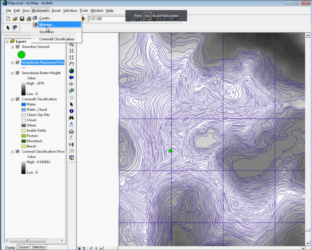
Later on, I also spent a lot of time working with ArcMap 9.2 (above), which I used in my programming skills to use VBA (Visual Basic Applications) code to create a map that made sounds – an area called sonification, which formed part of my early research interests.
Things have certainly changed in the 20+ years since 2003. ArcMap itself progressed from version 8.3 all the way up to the now retiring version 10.8.2. Of course we have also seen the rise of open source: QGIS in particular as a competitor to ArcMap, and now potentially better than ArcMap or ArcGIS Pro, depending exactly who you are and what you are trying to-do.
We’ve also seen the rise (again) of scripting. With R leading the way and Python a performing a quick catch-up, the combination of easier to use software and ease of access to the benefits of scripting has seen GIS become much more accessible than it was 20 years ago. Some colleagues who have been using GIS longer than I have remember the days of AML, ArcInfo and Sun Microsystems – all of which used command line interfaces to work with data. Much of this was to handle larger data sets than was easy to do in a graphical interface with limited computer resources – much the same situation we see now with big data and bigger computers – but still with limited computer power to process that data.
I was saddened to hear that some students are still being taught ArcMap:
For anyone teaching GIS now, ArcMap is not the tool to teach. It has been a long hard road of transition from ArcMap and I know moving software is not easy, but if anyone is still teaching ArcMap, I very much hope this is its final year. Of course anyone who would like help transitioning, ESRI provide a range of very good materials and I also have good consultancy rates – just get in touch!
One constant challenge in the geospatial environment is that the tools and technologies constantly change – and we see this across the board of geospatial. My advice to anyone coming into this area is to at least keep up with the changes and have an idea of what is happening, even if you don’t use the cutting edge in your own work. Much of GIS’s power is in its versatility and you can get 80% of this benefit with only learning 20% of the tools! Also that 20% of knowledge will easily transfer between QGIS, ArcGIS Pro, online web maps and many other GIS.
I’m really looking forward to the next 20 years, and who knows what it will hold?!
(Apologies to anyone who has studied English Literature, at any level!)
With nearly everyone participating in more and move video calls, “to share video or not to share video” is, indeed, the question. When participating in an online conference, should the audience members share their video?
We have all attended loads of video conferencing calls over the last 15 months, and I’ve been no expectation to this. I attended two conferences recently, and one thing that struck me was whether the audience members have their cameras on.
When I’m running a training course or presenting, I really love to be able to see people’s faces – so I can see who I am talking to. Of course, I realise this isn’t always possible or something the participants want to do (either because of bandwidth limitations, not having a suitable home environment [although this is less of an issue with virtual backgrounds now] or many other reasons). Therefore when I am running a course I explicitly say at the beginning: “If you can have your video on and would like to, please do. I really like to be able to see people. However if you have limited bandwidth, or another reason why you don’t want to share your video, that is fine as well.” With this approach 9 out of 10 people usually put their video on and it makes it a much better experience for me (and, I think for them).
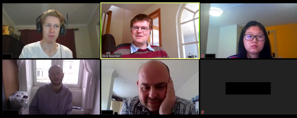
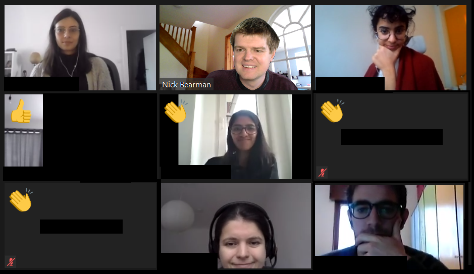
Participants in one of my training courses sharing their videos
I recently attended two conferences (AGILE 2021 and Coding in the Open), where only the people presenting shared their video, and the attendees did not. There have been many conferences like this, and at some conferences attendees do not have a choice (e.g. if you are using Zoom Webinar, the audience can not share their video).
However for these conferences, there was a choice (AGILE used a standard Zoom room, and Coding in the Open used Bluejeans). For AGILE, the organisers asked participants to turn on their cameras for a group photo! About two-thirds or so of people did turn their cameras on the for photo. However as soon as the photo was done, people turned their cameras off again.
There seems to be an unwritten rule that the audience have their cameras off, and I have seen this is many other conferences as well.
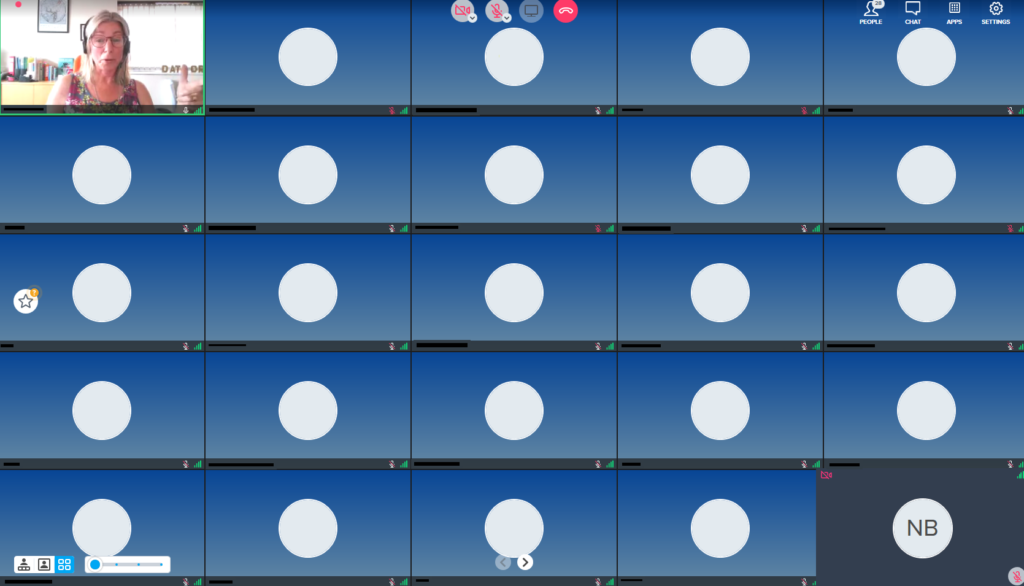
The blank boxes (with names and initials removed)
Personally, I don’t really like this, as all you get to see of the other people on the call are black boxes. Yes, you can turn off the blank boxes, but if I am presenting, I like to be able to see who I am presenting to, and if I am in the audience, I also like to see who the audience are.
The other conference I attended was Coding in the Open, and this was run on Bluejeans. Here the attendees were asked to turn of their video because of bandwidth. This is often a worrying concern, and here around 150 had signed up for the free conference, and the organisers were very worried that 150 people joining the call with video might stretch the limits of the platform. In the end, typically we had 40-50 people in each session, so wouldn’t have been an issue.
This is a very common concern for organisers, and compounded by the fact that for free events, often only one third or one half of the people who sign up actually appear. The question then is how much capacity do you need for this event, with additional capacity often costing more money. This is a discussion for another time though.
I did a rough show of hands in the session, and it seems most people would prefer to see the audience, whether they are in the audience or the presenter. Additionally, most programs have the option of hiding the video of other participants, if that is what you prefer.
As an aside, it is worth mentioning that you can turn your own video off in most platforms, and apparently this has been shown to reduce tiredness. I’m not sure it makes a lot of different for me, but for some people it clearly does:
Now that you can remove the icon video of yourself in Google Meet I am finding online meetings far less stressful. Seeing myself (however small on the screen) for the last 15 months has been horrible. I am happy to have my video on + be seen, but not as a mirror back onto myself
— prof jenny pickerill (@JennyPickerill) June 9, 2021
So if you think it might help you, give it a try!
I guess as we work out what the ‘new normal’ is, we will be creating new social rules and expectations for how we work, including in video calls. I would say please do share your video if you can – whether you are in a call of 2, class of 25 or lecture hall of 200. I think it makes all the difference to the person presenting!
Do share your experiences in the comments below and let me know what you think.
This blog post is the next in the series on running training sessions during the pandemic. As a recent Rasters Revealed conference there was a great session on running training courses during the pandemic and I thought I would share my experiences. This builds on my previous posts about teaching online and CPD.
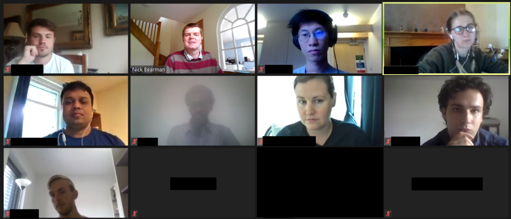
Since March I have run 10 different training courses, a mixture of 3 or 4 half day sessions. There is always potential to improve more, but I think overall my structure works reasonably well. I have certainly received great feedback from my course participants.
“I loved the interactive bits, the worksheets and the breakout rooms. They” were really hands on and felt like a normal course, even though the course took place online.”
Astrid Pape, PhD Candidate, Freie Universität Berlin Introduction to GIS, Geospatial Data & Spatial Statistics course, November 2020
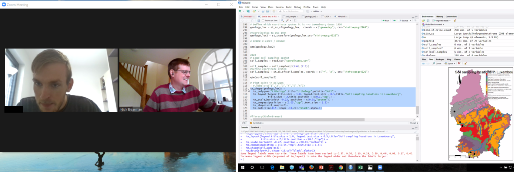
Screenshot of my teaching session in Jan 2021
I run the courses on Zoom, and limit the sessions to 3-4 hours maximum during a day – otherwise it ends up being a lot of intense screen time, which doesn’t help the learner, or me! Each session has a mixture of presentations (20-40 min) and then practical sessions. For the practical sessions, I split the main group up into small groups of 4-5 people using the breakout rooms feature. The practical sessions last for up to an hour, and I ‘walk around’ the groups by visiting each breakout room in turn and see how people are getting on. If they have questions, they can share their screens, and most of the time they group members talk to each other and share their questions within the group. They also have the option of pressing the ‘Ask for Help’ button which sends me a message, saying so-and-so has a question in room 2, and I can go to the room and see what their question is.
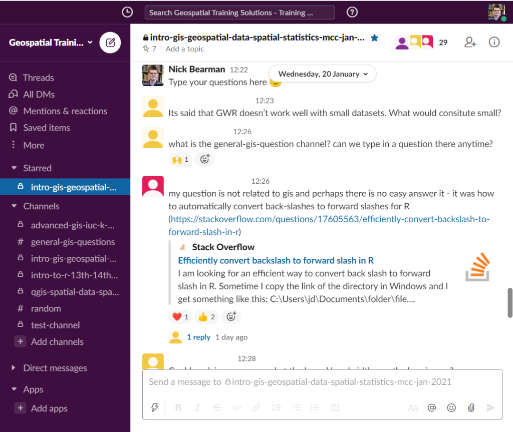
Over the whole period of the course (1-2 weeks) I run a Slack channel for that particular group. This allows me to share links to materials, slides, Zoom, videos, etc. as well as giving the students the option to ask questions to the group, or just to me (via the DM feature). During the actual sessions I also have 10 min at the end where I ask everyone to post a question in the Slack discussion about the material we have just covered. This is a great way of getting questions out of people and I then talk through the answers, adding in links later on if I don’t have them to hand there and then. All the sessions are also recorded and available to the participants (only) for 3 months.
Questions in Slack from a training session
I hope this is useful – if you have any experiences you’d like to share, please do in the comments below!
If you are interested in GIS training, then I have some courses coming up in Feb and April, and I am always happy to talk about running a course for your research group or organisation – just get in touch.
Our Professional Development Record (PDR) hours—CPD in the UK—are a key part of the surveying and geospatial professions. Previously PDR would have involved a mixture of in-person training, in-person conferences and self-study training materials. With the Covid-19 restrictions on meeting other people face-to-face, meetings are no longer possible, at least in the short term. Online video conferencing can substitute for some in-person events, and many PDR requirements are being relaxed to allow completely online PDR hours. So far, video conferencing has worked very well for training sessions and conferences, but I don’t think it will completely replace face-to-face meetings for a long time yet.
PDR requirements vary between industry and country, but all have some required training element, which would often be completed by attending in-person courses. This now all needs to be done online, at least in the short- to medium-term, and some accreditation providers have had to update their policies to allow this to be completed only online.
Providing one-to-one support during a training session. Video (left) and student sharing their screen (right)
In the UK, the Royal Institute of Chartered Surveyors (RICS) and the Chartered Institution of Water and Environmental Management (CIWEM) have one of the more formalized and strict PDR requirements. Both groups have moved all of their PDR courses online.
In the U.S., the GIS Certification Institute is completing its Technical Knowledge Exam online, and URISA (Urban and Regional Information Systems Association, one of the leading GIS professional bodies) has moved one of its in-person leadership academies online. In general, these events
have gone very well, but the online medium poses unique challenges of encouraging social interaction in an online space.
Certification for your PDR is also a tricky element depending on what area you are working in. Some of the certification elements can easily be completed online, using multiple choice answers or written responses to questions. Some of the more practical elements, like showing that you know how to service an RTK GPS unit, are tricky to examine online. I see a future where some of this might be done over live video calls, allowing the person being evaluated to demonstrate their skills to an assessor.
I run a number of small (10 to 20 attendees) in-person training courses in GIS and spatial analysis. All of these have had to move online, posing a range of different challenges. We all have access to video conference tools, and I think it is reasonable to say that some are better than others.
For most of my training courses I have used Zoom, which has worked very well with groups of up to 20 or so. My courses are a mixture of presentations (to the whole group) and then self-led practical workbooks, with the students receiving one-on-one support from me and a teaching assistant. I used the ‘Breakout Rooms’ facility within Zoom to allocate every student to their own room, and I could visit them and see how they were getting on, and they could share their screen if they were having any problems with their work.
Running a training course on Zoom.
This worked well, but we did miss out on the social aspect of the session – discussions over lunch, and students helping each other during the course. This is something that concerns many trainers and attendees alike, and I hope to see better solutions come along over the next few months.
I made use of the various security features in Zoom (particularly the Waiting Room) so we had no issues of Zoom bombing, where unauthorized viewers gate-crash the meeting and disrupt events. Moving courses online has allowed many more people to take part, particularly those who would otherwise be unable to travel for whatever reason. I have run several courses where participants have said it is great that the course is online, as otherwise they would be unable to take part, due to childcare requirements.
This increase in numbers has also been seen in bigger conferences and MOOCs, with a big uptick in numbers. For example, the very popular ESRI
Cartography MOOC (Massive Open Online Course) reached more people than last year (35,772 participants in the latest offering) and has also had a 31 percent higher completion rate. Some smaller GIS conferences that would usually run in person have also received an up tick in numbers from moving online, including FOSS4G UK 2020, which went from typically 100 attendees to 400, GISRUK 2020, which went from typically 150 to 300 and QGIS North America 2020, which went from typically 50 or so to 200.
Nearly all of these conferences are also now available as recorded videos online, providing a great resource for future learning. It is great to see these increases in numbers with more people learning what GIS can do and being able to apply it in their own areas of work.
While the move to online has many advantages, I don’t believe it will entirely replace in-person training and conferences. The social interaction element of online conferences has so far seemed the hardest to replicate online.
There are some very interesting platforms to encourage networking, but I’ve not yet seen any that work really well. I can see everything staying online until the end of 2020, but beyond that I see a hybrid model going forward, where there will be substantially more online events than before, but there will still be some in-person events.
Whether we can manage to run great hybrid events with links between the group physically in the room and the group online remains to be seen.
PDR Requirements in the U.S.
Licensure for land surveying varies from state to state, but there are more similarities than differences. Typically, licensing is handled by a state board of professional licensure, often the same board that oversees engineering licenses.
The requirements for licensure by state are similarly defined in the laws, codes, and statues for each. The requirements are typically a combination of experience, education, and examinations. Most require passing one or more standardized set of tests from the National Council of Examiners for Engineering and Surveying (NCEES), a non-for-profit organization dedicated to advancing professional licensure for engineers and surveyors.
Most states have adopted continuing education requirements and often the reporting of one’s hours is up to the licensee but is subject to an audit. Sometimes the requirements are stated as “units” and other times as hours, and the annual requirements are typically about 15 hours per year.
The resources for education credits or hours are typically met from educational institutions, surveying association/society conferences and seminars, and commercial education credit firms. There are a number of nationwide firms offering these, like PDH Academy and GeoLearn, some presented locally and others online.
Since the beginning of the pandemic, there has been a sharp increase in surveyors tapping online resources, and in turn, there has been a rise in online resources. Some states surveying associations, like West Virginia, have rapidly increased online course offerings.
For GIS professionals, the GISP certification, via the GIS Certification Institute (gisci.org), is broadly viewed as the standard. While it is not a license, like those required by states for surveying and engineering, the GISP can be a job application or contract requirement like other professional certifications. This is similar to the Certified Survey Technician, hydrography surveyor, and floodplain surveyor programs of the National Society of Professional Surveyors.
The GISP recertification requirements are a points system, based on a combination on education, contributions to the profession, and work experience. GIS is, by nature, very digital, and so is GIS education. Many resources for online education and collaboration were well established even before the pandemic began.
Using Microsoft Teams for delivering remote teaching
I’m sure there will be manyposts about the online teaching we have been doing as a response to the coronavirus outbreak, and subsequently working from home. For my teaching at UCL, I have only had to do one session, and this was completed as a video call on Microsoft Teams.
I had relatively little time to change my teaching plans, with the decision to remote teach being made on Friday 13th, and my lecture scheduled for Tuesday 17th. My teaching group is small, only 7 students, so I decided to teaching the session live, as planned, but over video conference rather than in person. Setting up the team for the module on Microsoft Teams was straight forward, and I added all of the students on Sunday afternoon – and asked them to confirm, via Teams, that they have installed it successfully.
By Tuesday morning, all but one student confirmed through the chat on Teams that they had it up and running. I contacted the student who couldn’t, and they were unavailable for the session, and asked if I could record it. Recording has its’ own pros and cons discussed in manyotherplaces, but I decided I would be happy to record this session, and then delete it after it had been used. I messaged the other students to see if anyone objected, and nobody did.
I did a test call to experiment with the recording options (which were new to me). I have used Teams for video calls before, but if you haven’t I would recommend you have a test run through before the real thing.
I started the session 15 min before it’s scheduled time, and it took that long to get everyone added and check they could all hear me, see me and see the slides. Whilst actually giving the lecture, I found it a bit disorientating, as only 1 student out of the 6 had a video camera, the others were on audio only, so I couldn’t see them. It was hard to get visual feedback that they could see/hear/understand what I was talking about. I did stop a couple of times during the session to check all was being seen/heard/understood, and got some ‘yeses’ back, so that was working as planned.
This is a screenshot from my setup (with names and initials blanked out). I have a laptop with a separate monitor, so had the video chat on the external monitor and the slides on the laptop. My webcam is built into the laptop, so this meant I could look at the slides and be looking directly into the camera.
I didn’t have the opportunity to complete a discussion session in this format, so I don’t know how well that would have worked. I did ask for feedback on how the session went.
The feedback was positive, although sometimes there was a delay between when I changed the slide, and when it changes on the students screens (I used screen-sharing for showing the slides, as I couldn’t see how to do PowerPoint slide sharing within Teams, although supposedly it is there).
Students’ impression of Teams is very positive, particularly for modules with group assignments and the ability to add staff to chats.
One student said to me that they would definitely support additional lectures in this format!
My key hints and tips:
Test the software with plenty of time to spare
Make sure the students have good notice on which software you are going to use
If possible, confirm with the students that they have the software setup and working
It is better if students have video as well as audio, but audio only will work
During the session, make time to get feedback from the students – is everything working as it should be?
Be patient with yourself – we are working in extraordinary times and everyone understands this, so it won’t be perfect
So overall, it went fairly well I think. It’s not the same as in person teaching, but worked at short notice in a pinch. Any comments are welcome, and please do share your own experience.